Surveying Services for Wisconsin STH 13 Wayside Revetment
MSA was asked to survey a challenging 900-foot stretch of shoreline along the south shore of Lake Superior in Port Wing, Wisconsin. The shoreline has experienced severe erosion over the last 40 years due to wave and ice impacts upon the highly erodible clay soils in the bluffs. Recent high-water levels of Lake Superior have also been accelerating bluff sloughing, threatening to undermine a scenic wayside overlook along State Highway 13.
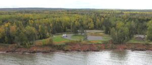
The project provided unique challenges as portions of the site were inaccessible and unsafe due to erosion. Additionally, deposits of driftwood and debris littered the shoreline, making it difficult to survey by traditional manned methods. MSA also needed to gather modeling aspects of lands underwater. This combination of a large survey area and need to collect data of varying depths made it impossible to locate with GPS or a robotic total station alone. Even though the site and terrain were complex, MSA was able to leverage cutting-edge technology and a variety of tools to be successful.
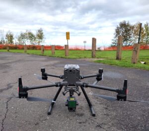
Topographic digital terrain models and surface data were created using a combination of traditional survey methods and an unmanned aerial flight via drone utilizing LiDAR. LiDAR (Light Detection and Ranging) is a remote sensing method used to examine the surface of the earth. Light is emitted from a rapidly firing laser, and as the light travels to the ground, it reflects off things like buildings, vegetation, and bare ground. The energy returned, and the time it takes to be returned, is recorded to determine surface type and then categorized so that it can be filtered later. The unmanned aerial vehicle (UAV) is also recording the altitude, GPS location, and orientation so that the LiDAR data can be used to create a three-dimensional surface of the site — in this case, roughly one-half a mile of shoreline frontage along Lake Superior.
With flight parameters set, pre-flight checklists completed, a pilot in command and visual observers ready, MSA efficiently conducted multiple flights to collect over 100 million data points and nearly 2,000 orthophotos to process, filter, and build a detailed surface model of the site.
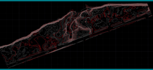
Contours generated from point cloud data from LiDAR.
MSA also gathered bathymetric data for the lakebed survey utilizing SonarMite — a small, portable hydrographic echo sonar system — to map the lake floor. The SonarMite was towed behind a motorboat in slow, serpentine patterns, to cover the half-mile area offshore, connected to a GPS unit to map the depths with optimal spatial accuracy. This lakebed survey was done to complement the survey of 1,500 feet of shoreline already underway.
After data was collected from both the shoreline and lakebed, MSA meshed both the terrain and bathymetric data together to create one seamless surface model, confirming confidence in the data through standard quality control methods. The result is a comprehensive reality capture of both surface and lakebed topographic data to inform shoreline remediation work at this complex project site.
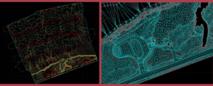
Meshed digital terrain model showing both contours and as a Triangulated Irregular Network (TIN).
Client
Wisconsin DOT
Location
Port Wing, WI
Services Provided
Contact Project Lead

Emily Pierce
Senior Project Surveyor