GIS for Stormwater Agreement Management
In 2023 the City of Middleton asked MSA’s GIS team to develop an improved tool for tracking municipal stormwater agreements. The City’s existing system was built upon the Microsoft Access platform and was extremely robust as a relational database system — tracking agreements, biennial inspections, and all PDF attachments. MSA’s challenge was to convert the City’s tabular stormwater agreements database into a spatial GIS data solution that would better organize the collection, storage and updating of documents over time.
What’s the significance of stormwater agreements?
Stormwater agreements are documents drafted between land developers and municipalities to outline the construction and subsequent maintenance of stormwater management structures (typically stormwater retention ponds) by landowners. The maintenance of these structures is extremely important for flood prevention and nutrient runoff reduction during storm events. The stormwater agreement — paired with documentation from routine inspections — provides proof of functionality of the stormwater management structure/s as well as adherence to a maintenance schedule, which in turn, can earn municipalities incentives from the state. As such, municipalities need to keep track of not only the original stormwater agreement, but any related inspection documents.
Historically, these agreements have been in a paper format — kept in a filing cabinet and prone to disorganization or even misplacement. Middleton’s existing system operated by scanning original stormwater agreements and inspection documents and converting them to digital PDFs. However, it was becoming a challenge to spatially understand where agreements existed and where inspectors needed to be dispatched. MSA’s goal was to develop a custom GIS solution that would rival, then improve upon the existing platform. This solution needed to be built from the ground up.
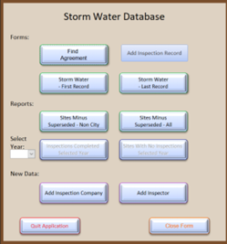
Access Database
MSA utilized the new Experience Builder tool from ESRI to get started. This environment provided all the requisite components to create a unique, tailor-fit GIS solution that introduces more sophisticated data analysis and reporting functionality than its predecessor.
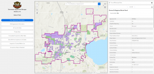
GIS Solution
Being that this was a custom design for the community, there were no existing similar applications that could be used as examples during project planning — aside from the Access database itself. City staff were instrumental in providing input regarding what functionality was required that would be similar to the Access database and what new functionalities could be leveraged with the power of a GIS-based system. Experience Builder allowed MSA to create a control panel-style application for City staff to view, edit, and then query stormwater agreements. This new application provides a spatial look into previously tabular data and delivers new ways to visualize and manage stormwater agreements.
Users can easily geo-locate existing stormwater management structures within the community, view current agreements, edit agreement information, track the scheduling and completion of inspections, file acceptance reports and send contact mailer lists. These mailing lists are compiled to contact landowners who need to schedule a routine inspection as well as to contact those who were not in compliance during their last inspection — and need to perform maintenance to restore functionality to their stormwater structure. GIS provides the ability to add attribute fields to each polygon to track compliance and inspection cycles. By querying these attributes, the mailing lists can be built automatically — saving municipalities time and hassle.
Client
City of Middleton
Location
Middleton, WI
Services Provided
Contact Project Lead

Calvin Wong
GIS Technician