Mount Joy Stormwater Drainage System Modeling & Analysis
Mount Joy is an unincorporated development located in Scott County, Iowa, just north of the Quad Cities metropolitan area. MSA was asked to evaluate an approximately 150-acre fully developed industrial/commercial site, which had been experiencing frequent flooding due to undersized and deteriorating drainage pipes.
The area was originally developed with Hwy 61 passing directly through it. However, when Hwy 61 was redeveloped, an interchange was added and the highway shifted to the east, converting the road running through Mount Joy into a cul-de-sac. The County suspected the road had never been fully reconstructed and, as a result, the pavement was in poor condition.
The area did have a storm sewer system, but at some time in the past, portions of the storm sewer had been filled in. The trunkline of the storm system ran through private property without easements, meaning the County had no method to maintain or repair the infrastructure easily. They also did not have any maps of the existing storm sewer system and there were known reports of flooding in the area.
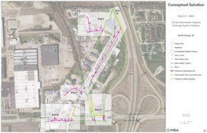
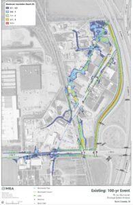
To develop solutions to these issues, MSA utilized 2D XP-SWMM hydraulic modeling software to evaluate the site and complete a survey of the entire storm sewer system consisting of 67 storm pipes totaling over 7,700 feet in length. MSA’s field observations determined that the entire storm drainage system was in extreme disrepair. MSA further ascertained via modeling that, despite repair conditions, a significant portion of existing drainage infrastructure was also undersized, putting the many existing commercial and industrial buildings at flood risk. Traditionally, storm sewer in this area had been sized to serve the 10-year flood event, but Scott County wanted to be proactive and size the new storm sewer to serve the 100-year rainfall event.
The flood mitigation solutions evaluated focused on improved drainage within public rights of way, providing the County with easy access for maintenance. Sizing pipes for the 100-year event is a big undertaking, as large pipes are challenging to fit within the site constraints. To reduce the need for such large pipes, the upstream 1/3 of the watershed was diverted away from the new piped infrastructure toward an existing large drainage ditch along STH 61. This existing ditch already had capacity for more flow; this means the newly installed pipes could be smaller and save the County some funds. MSA assisted the County in obtaining the DOT permit to work within the highway right of way by conducting additional detailed analyses of flow conditions and completing a design alternatives analysis to evaluate necessary changes to grading along the highway shoulder to create the necessary ditch capacity within a hydraulic pinch point in the ditch. MSA was able to demonstrate that changes to an existing drainage ditch profile would not result in steepening of slopes within the traffic runout area nor require acquisition of additional right of way on the opposite side.
MSA’s stormwater analysis dovetailed into the formal design for the project. Stormwater professionals partnered with the civil design team to transition the modeling recommendations into construction documents.

The project morphed midway through design, when the County received notification that new development was occurring in the area, with a new gas station and other businesses planning to grow in the very near term. Because of this, MSA involved its traffic engineering team to understand the changing traffic patterns and recommended how the design could best be altered to accommodate the increased traffic patterns. Several options were presented to the County, and they ultimately selected a roundabout, as it would provide the best traffic service to the new gas station and also increase intersection safety.
The design also included two railroad crossings. Although the region does not have much railway traffic (1-2 trains per week), coordinating with the railroad added an extra level of complexity to the project. MSA assisted the County in obtaining the railroad permits required to complete borings for the stormwater pipes underneath the tracks.
MSA’s comprehensive analysis, modeling work, and recommended improvements were approved by Scott County and construction plans completed in the summer of 2024. The County is working to implement the design improvements in 2025, which will result in sustainable flood mitigation solutions for the foreseeable future.
Client
Scott County, IA
Location
Mount Joy, IA
Services Provided
Contact Project Lead

Amber Converse
Water Resources Engineering Project Manager